 |
| WEST TEXAS RANCH LAND - This ranch land is located about five miles south of Marathon in eastern Brewster County. If you can picture this scene without me, the windmill and the brown water tank in it, you are picturing what eastern Brewster County looks like: Hundreds of square miles of huge ranches with scrubby land like this and mountains always in the distance. The land is so parched it takes more than 50 acres to produce enough grass to keep one cow alive. |
April 4 brought yet another good trip with Tom Shorrt, this one down through eastern portions of Brewster County to the ghost town of Lalinda on the Rio Grande.
A series of mountain ranges running north to south - the Glass, the Del Norte, the Santiago and the Dead Horse Mountains - split the county. U.S. 90, which runs east-west in the northern portion of the county, is the only road that passes through the mountains to tie together the two halves of this enormous, 6,192 square mile county. It appears to me if you live in Alpine, which is where two-thirds of the county resides, and which is west of the mountain divide, you tend to stay in Alpine. The only town in east Brewster is tiny Marathon, pop. 430. If you live there, you are liable to go to 57 miles to Fort Stockton in neighboring Pecos County for your shopping needs, instead of the 30 miles to Alpine. Why? Fort Stockton is considerably larger than Alpine AND has a WalMart, which Alpine does not. Thus I sense that west and east Brewster County, while one, are more like neighbors than family. In fact, there was a time when east Brewster was actually two separate counties, Buchel and Foley. But the two never gained enough people in them to organize a county government, and the state legislature eventually abolished them and added their territories to Brewster County.
So, on a fine morning, Tom and I headed to eastern Brewster. I wanted to see Pena Colorado, an oasis that used to be the site of a cavalry fort, and the locally well known Stillwell Ranch. In addition, Tom thought I should see Lalinda.
 |
| PENA COLORADO - A very productive spring creates this pond in a remote Brewster County park called The Post. It takes its name from the fact an Army post called Camp Pena Colorado was located here in the late 19th Century. It would be a pretty spot anywhere, but in the endless high desert country of Brewster County it is absolutely beguiling. You just don't want to leave. |
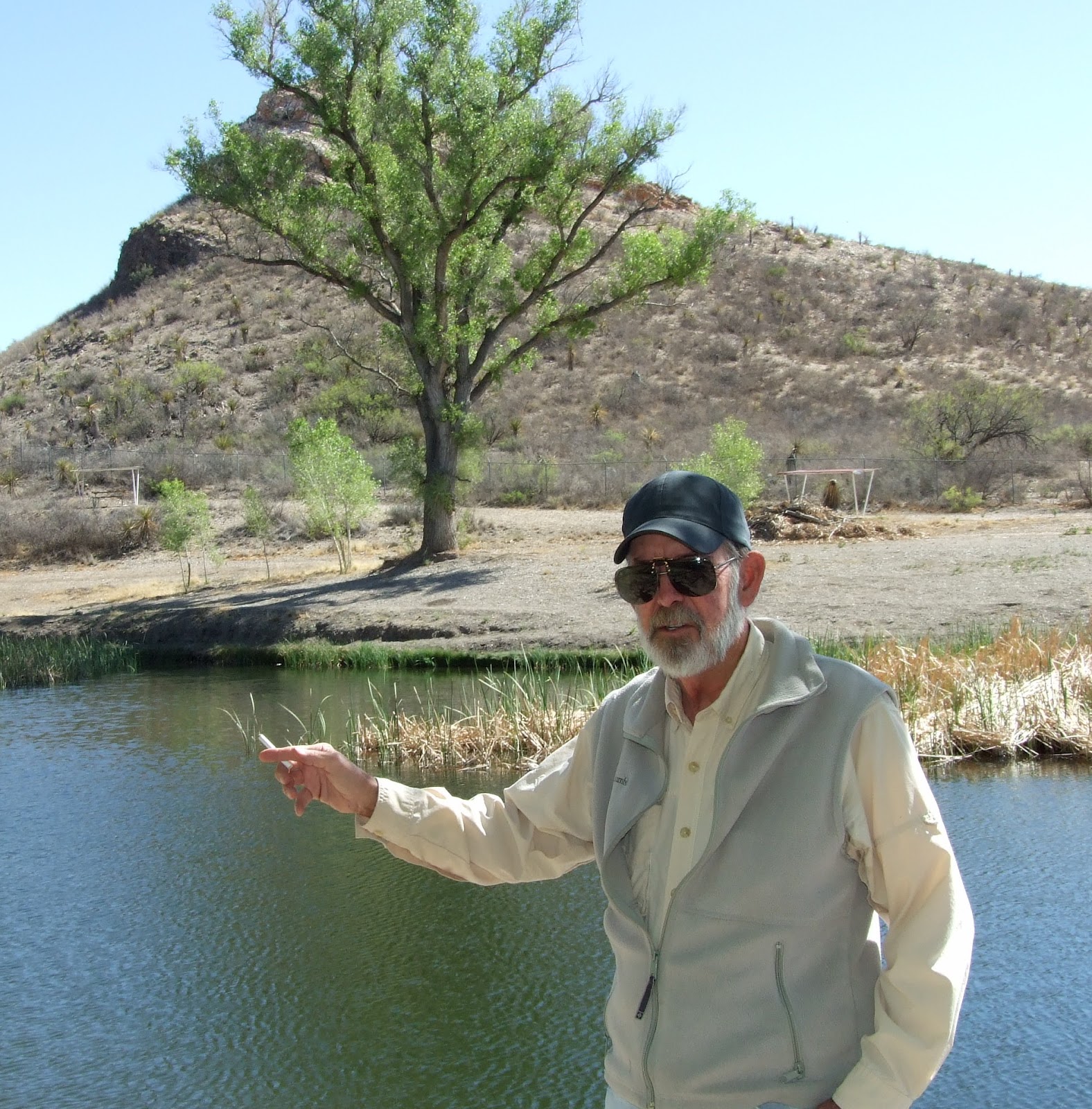 |
PORKY'S DEMISE - The camera catches my cousin and
guide, Tom Shortt of Alpine, standing beside Pena
Colorado Spring recounting the demise of his "friend,"
Porky. Porky was a really bad hombre who had done a
lot of bad things to people and, consequently, had a lot
of enemies. Porky was found weighted down with chains
and bricks at the bottom of the spring. His death was
ruled an accident. For local color, you can't beat having
Tom as a tour guide around these parts.
|
Pena Colorado is now a five acre county park, called The Post, with shade trees, green grass and public facilities such as rest rooms and picnic tables and, of course, the spring. The spring had been dammed up creating a pond about one acre in size, which is an ocean out here. Swimming and fishing are allowed. There are catfish and stocked trout. The spring appeared entirely unaffected by the drought. The pond was full to the brim and water was running over the spillway at a rate similar to a garden hose. It was a beguiling place.
It was about 45 miles of empty land to the next stop at Stillwell Ranch. In the distance on both sides were rugged, naked mountains. We were passing through what seemed a limitless desert area with nary a soul nor building in sight. I was lucky to have Tom along to point things out. He would announce something like, "We just crossed Maravillas Creek, which is the biggest waterway in this section of the county." I saw a bone dry gully. Or, "Now we are on the Combs ranch, which is where Susan Combs lives. She might end up becoming our next governor." I saw only miles and miles of desert identical to what we had been cruising through for half an hour, but Tom's information now caused me to look upon this particular patch with new respect.
 |
| STILLWELL STORE - Located on the Stillwell Ranch in the Chihuahuan Desert in southeastern Brewster County is the only civilization for at least 40 miles in any direction. Stillwell Ranch is actually a sort of resort .... sort of. Besides the store and gas pump, with above ground tanks, there are a few RV sites, a bath house, a museum and a gift shop. There is nearly zero traffic on the road, and it is exceedingly quiet there. Rocking on the store's porch, the rest of the world seems far, far away. |


 Roy R. Stillwell established his ranch in 1906 some 40 miles south of Marathon and 20 north of the Rio Grande. Even a ranching know-nothing like me could see it was poor land, parched and with little grass. Luckily he had a lot of it - 32,000 acres. It was enough to run 600 mother cows. That comes out to 53 acres per cow. It takes only one acre to support a cow in Virginia. In 1918 he married Hallie Crawford from Alpine. She was quite a character. She arrived with her parents and siblings in Alpine in 1910 - in a covered wagon. She did many things in her long life that ended just shy of 100 years. Her husband was killed in a pickup truck accident in 1948, and she would live on another 50 years. Her son took over management of the ranch, though she remained involved and often worked there on weekends, where they opened a country store and, eventually a small RV park. For the most part, however, she lived in Alpine where she was a justice of the peace for many years. In addition to ranching, being a judge and keeping store, she also served at various times as a teacher, newspaper correspondent, president of civic clubs and authored a couple books, among other things. She became enough of a community pillar and locally beloved figure that, during the last few years of her life, area people donated money to build a museum about her life next door to the ranch store. The Stillwell Ranch is now a minor tourist destination in the middle of nowhere, perhaps especially for RVers. There is the store which, in addition to selling camping supplies, has a small gift shop, sells rocks and dabbles in homemade food, especially delicious burritos. There is a fairly decent bath house that has signs instructing people to put absolutely NO PAPER in the toilets. A waste basket is beside each toilet into which soiled paper is to be dropped. Gross! (Apparently they have septic system problems. There are various out buildings containing workshops, a single gas pump fed by above ground gas tanks. There are about 10 RV sites, the Halle Stillwell Museum, and occasionally live entertainment.
 |
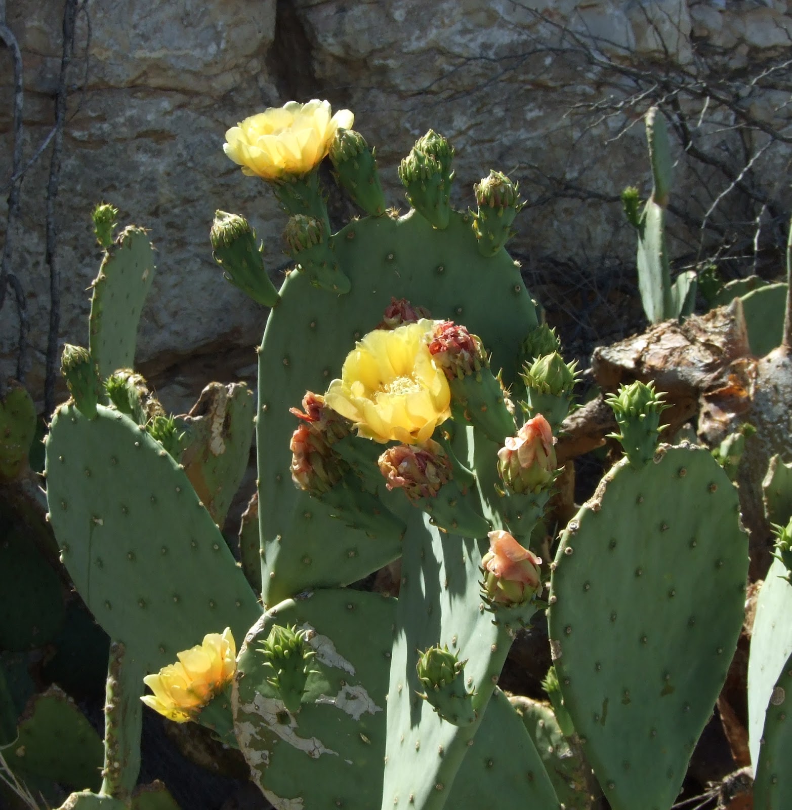
DESERT IN BLOOM - Winter has been mild
and spring has come early in Brewster County.
But the drought has been fierce. Many desert
plants are dead, but some survive where
underground water still remains or, strangely,
along roadsides. These were photographed in
eastern Brewster County April 4: Top, hedgehog
cactus (or so I think). Second from top, Spanish
dagger yucca. Third from top, prickly pear.
Bottom, ocotilla (oak ah TEE ya).
|
When Tom and I arrived there were two RVs and a small group of motorcyclists. We went into the store, which was being tended by a woman in her 60s who turned out to be Hallie Stillwell's granddaughter. She told us that the ranch, "what's left of it," is still in family hands, but times are tough. The drought has dried up two of the three wells on the place, and forced them to sell their last 100 cattle. Tom and I sat on the store's comfy porch and ate our burritos. The motorcyclists roared off toward Marathon, leaving dead silence in their wake. Sublime peacefulness as I rocked on the porch looking contentedly at the low, desert hillside across the road. However, it wasn't long before a truck bearing muddy conoes and a van carrying the sunburned canoeists pulled into the dooryard. Noise. They had just pulled out of the Rio Grande somewhere near Lalinda, and stopped at the store to have lunch. They spoke a foreign language and appeared to be from Europe. The river level is so low that it is difficult to find a place to run boats. In some places it is little more than a string of puddles, and the canoeists have to drag their vessels over the low spots. One fellow told me running the river is currently more like a "canoe assisted hike."
Tom and I went into the Hallie Stillwell Museum. It was a sturdy adobe with unusually high ceilings for an adobe. It was set up like a house with a huge living room, a large foyer, kitchen and two other rooms, all filled with Hallie Stillwell momentos, her hats, her cook stove, her guns, pictures of her family and her husband's, her furniture and so on. It was more interesting than I expected.
The road to Lalinda was a roller coaster but well paved, thankfully. Desert plains, desert hills, desert mountains, desert dry creeks. All of it stony, creosote and cactus covered land, and getting warmer by the mile as we descended down to the Rio Grande. Many of the desert plants were obviously dead because of the drought. Tom said he had never seen it so bad. Even the lechuguilla (letch ah gee ya (gee as in gear)) is dying off. Lechuguilla is a plant that looks like yucca and is considered by bilogist to be a "marker plant" for the health of the Chihuahuan Desert. We crested one more roller coaster hill and at last looked down into the Rio Grande Valley. One little white spot at the bottom, miles from us, was an abandoned Catholic church in Lalinda.
 |
| RIO GRANDE VALLEY AND LALINDA - The hilly road from Stillwell Store to Lalinda finally reached the spot (above) giving a grand view of the Rio Grand Valley. Note the little white spot at 10 o'clock above my right shoulder. That is an abandoned church and the only structure that can be seen in Lalinda from this point. It and the mountains beyond are in Mexico. Driving further down into the valley eventually brought us to the view of Lalinda below, showing the fluorspar mill on the left, the "downtown" in the middle and some of the residential neighborhoods on the right. Lalinda was a company town built by Dow Chemical to house its employees at the mill and mine. Now here it lies, an entire town abandoned, probably less than 20 years ago. A patch of the Rio Grande can be seen just right of center in the foreground. |

Coasting down into the valley, the rest of Lalinda and the mining company's processing mill gradually came into view on the Mexican side of the river. Then we came to the end of the road, the Gerstaker (gurh STACK urh) Bridge. Lalinda was a company town. Dow Chemical mined fluorspar in the hills beyond Lalinda, brought the ore to the processing plant in town and then loaded the milled product on trucks to cross the Gerstaker into the U.S. and head north. I presume the town with its fairly nice homes was built for the company's upper level local staff employees, likely American, such as managers, engineers, supervisors, accountants and upper level storekeeping and clerical people. The surprising thing about Lalinda is it's new. The houses are modern, American looking buildings arranged in neighborhoods. They and the mill all look like they could be quickly put back into operation. On one of the town streets I saw what looked like a large, nearly new Caterpillar back hoe with flat tires. Abandoned. It would have been fun to cross over the river and poke around, but of course that would have been risky. As Tom says about this big empty country, "It looks like there is no one around, but there is always someone around."
 |
| GERSTAKER BRIDGE - Tom Shortt photographs the Gerstaker bridge built over the Rio Grande by Dow Chemical in 1964 and closed by the Mexican government in 1997. Dow built it to carry truckloads of mined fluorspar from the mill in Lalinda north into the U.S. The town is just out of camera view to the left. Though modern and still in good shape, the bridge is just barely wide enough to allow passage for a big truck. It is blocked with a steel, cage-like fence plus several New Jersey barriers preceding it. Look carefully to the right on the far side of the bridge. A white building is visible partially rising above the brush. That was the Mexican customs building, and it is where smugglers shot three Mexican border guards, two fatally, causing the Mexican government to close the bridge. |
I don't know when the mine opened and Lalinda was built. I do know, however that Dow built the bridge in 1964, and the Mexican government closed it 1997. The area is known for smuggling, especially exotic, illegal animal furs. In 1997 a shootout erupted on the Mexican side of the bridge between some smugglers and the three border guards on duty. Tom surmises the border guards were demanding more of a bribe than the smugglers were willing to pay. At any rate, two of the guards were killed and the third one was left for dead. The Lalinda mining operation may have already been closed by then, however.
We took pictures and studied the Mexican side with binoculars. It was very warn, Tom guessed the low 90s. Back in Alpine, 3,000 ft. higher, is was in the 70s. We hopped into the van, cranked up the AC and began the roller coaster ride back to Stillwell Store and then on to Marathon. On the way we stopped at a roadside picnic spot so I could take pictures of a blooming yucca. In thick brush beside the road, just inside a barb wire fence, Tom spotted a long dead Hereford. It was a skeleton, but amazingly its hide was still intact and wrapped around the bones. Tom pushed his way into the brush and picked up the skull with horns and even the white forelock hair across the brow still intact. He said he always wanted a skull like that, so into the van it went to live forevermore on the Shorrt Ranch in Alpine. I like to think I participated in a Texas cattle drive. As we drove off from the picnic area, I inquired if we were now guilty of cattle rustling, but Tom opined the owner, who he knew, would probably not prosecute us. Probably?


 |
| MORE VIEWS OF LALINDA - Top, the Lalinda mill with the "downtown" area to the right. The Rio Grande can be seen at right just below the centerline. Middle, a closer look at the abandoned mill. Bottom: I climbed over several New Jersey barriers to get far enough out on the Gerstaker Bridge to get this camera angle, which shows the Rio Grande as it flows downstream from under the bridge. "Downtown" Lalinda is at upper left, while residential neighborhoods sprawl from there to the right. Nothing was moving over there. It appeared completely empty. The American style houses appeared to be still in pretty good shape, though definitely abandoned looking. It's surprising to me that Mexicans living in the area haven't torn them apart for salvage. |
No comments:
Post a Comment