|
| ALPINE - Taken from the side of Hancock Hill on the east side of Alpine, this photo looks across the downtown area of Alpine to Twin Peaks, aka Twin Sisters, which the city has adopted as its emblem. It's altitude is 6,054 ft., but since the Alpine Valley floor where the city sits is 4,480 ft. above sea level, the height of the mountain above its base is 1,574 ft. Alpine is full of trees, but they have all been planted by residents over the years. Originally Alpine was as treeless as the surrounding high desert land is to this day. |
In a few days I will end my two-month sojourn in Texas and return home. For my final post, I am sending a potpourri of scenes from what has been my home away from home here in West Texas - the City of Alpine. I've gotten rather fond of the place. This post will be mostly pictures to give an idea what the Alpine looks like.
 |
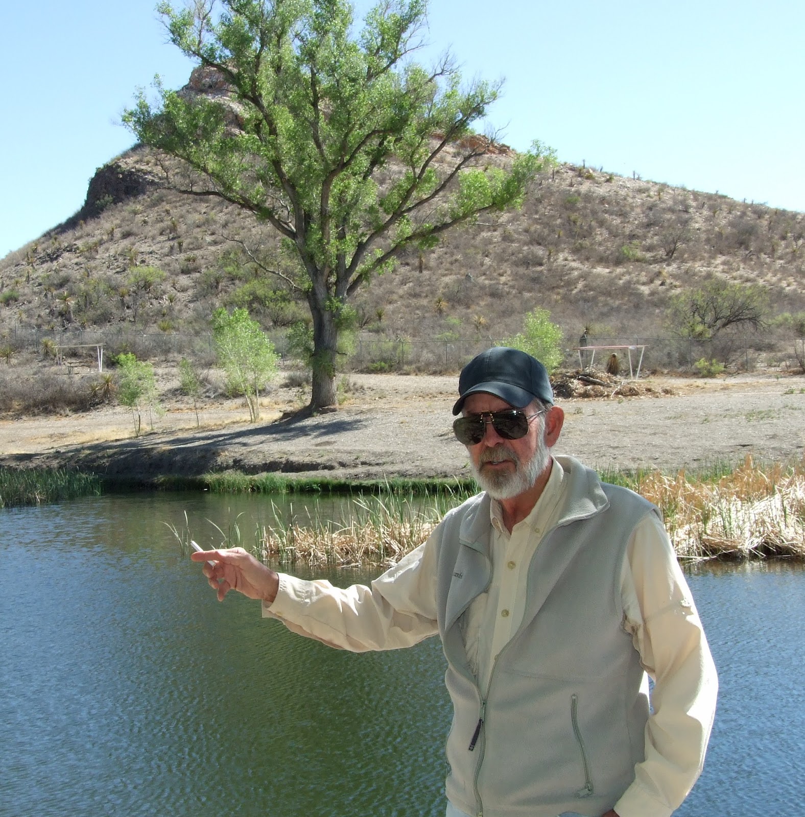
BURGESS SPRING - When the spring is flowing, this dry
low spot is a small pond. The gold stubble was golden rod,
which died and has been chopped down. The spring is
named after John Bugess, a freighter whose wagon train
was attacked at the spring by Apaches and who managed
to fight them off. The spring was the reason the Southern
Pacific established a water stop here for its steam
locomotives. Alpine soon sprouted around that water
stop.
|
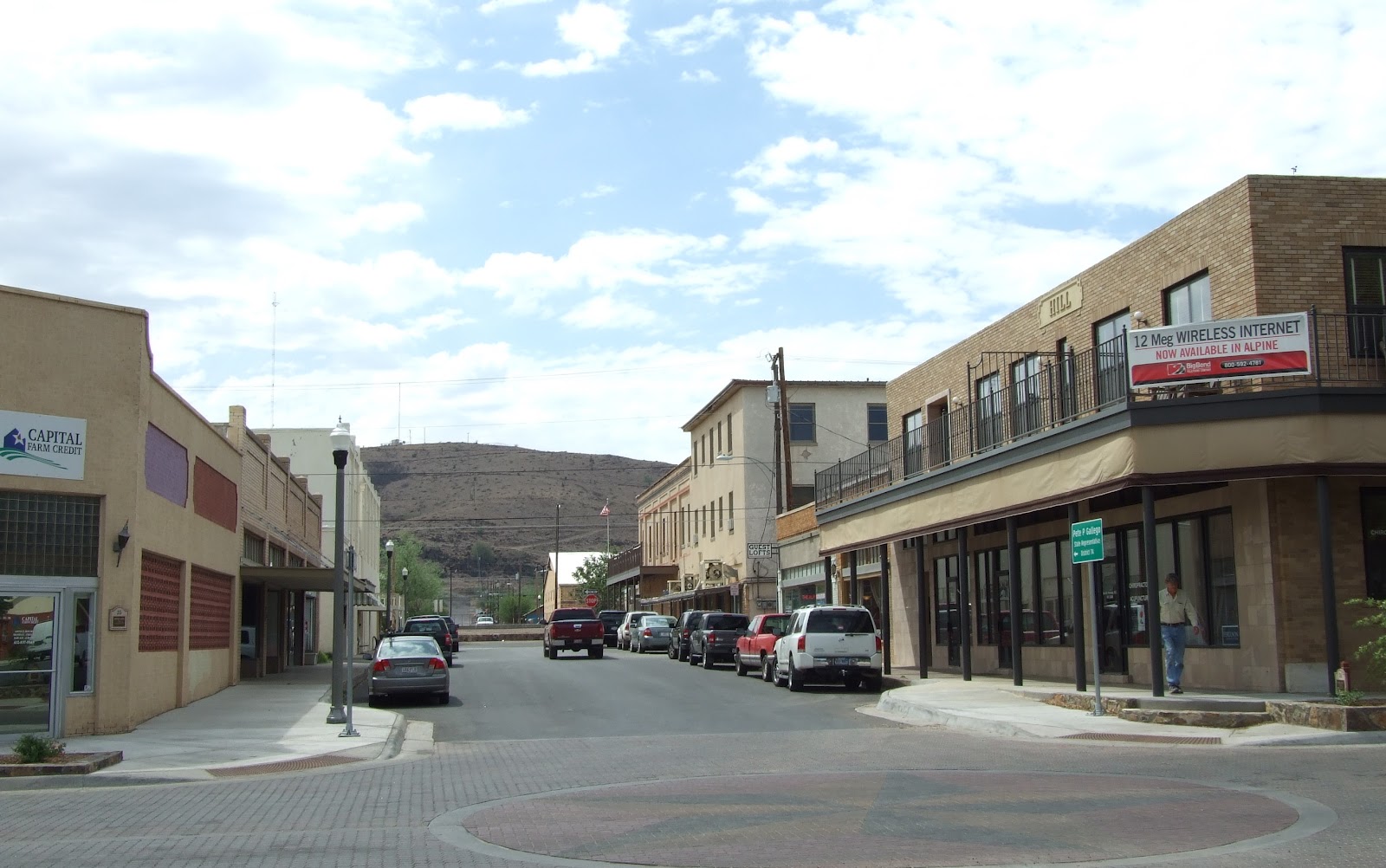
For a little town, it has a lot going for it. It is the county seat of Brewster County and the home of Sul Ross State University and the only hospital in the entire Big Bend. It is a ranching, banking, shopping, distribution and commercial center for Brewster as well as, to some degree, surrounding counties. It is an attractive town, with a clean downtown and mostly full storefronts, many fine homes and a scenic setting in a mountain valley. It has numerous hotels/motels and restaurants, including a 24-hour diner. It has a busy private airport and it is an Amtrak stop on the Southern Pacific Railroad. There is a excellent regional Big Bend history museum, a new library and increasingly Alpine is developing as an artist community. There is a large Border Patrol station, a U.S. Courthouse, a large DEA facility, and area TDOT and state police headquarters. There also appears to be an unusually busy civic life, with clubs, churches, the the university and the public schools always offering events for the public to join or attend.
A large spring, called Burgess Water Hole (currently Kokernot Spring), put Alpine on the map long before there was a town here, or for that matter, before there were maps. The spring was used by the Comanches as part of their war trail system, and after they had been defeated, by the Mescalero Apaches. It was used by Europeans as early as 1683 when a Spanish exploration expedition passed through the area, and in the 19th Century it was used by freighters along the Chihuahua Trail.
 |
| ALPINE STATION - There was nothing but desert in Alpine until the railroad arrived in 1883 and made Alpine a water stop. Ranchers brought their cattle to the stop to be shipped, and soon a depot was built, circa 1884. It was built so early in the town's history that it preceded any churches, so town resident held Sunday services in the depot waiting room. Today's depot is the fourth to stand on the spot, the previous three having burned. And it is no longer a working depot. Amtrak makes three stops per week for passengers - the waiting room is still available - and freight trains run through town several times per day and night, stopping only to change crews. Livestock and freight no longer come or go by rail from Alpine. BELOW: As it has always been, the tracks run straight through downtown Alpine. Running on the north side and parallel to the tracks is Holland Street, which is the main downtown street. The Holland Hotel is just across the street from the station. The original hotel is the tan two-story building on the right. The larger white building to its left is "the annex," opened in 1927. The social center of town for decades, the Holland closed down in 1972. However, in recent years new owners have been fixing it up and trying to make a go of it. I prowled through the lobby and meeting room areas and found it thick with early 20th Century western charm. |

However, no town grew at the water hole until 1883 when what became the Southern Pacific Railroad finished building tracks from El Paso across the Big Bend to Del Rio. The rail passed within a mile of Burgess Water Hole, and a railroad camp was established there to water the steam engines from the spring. It was not long before the railroad water stop attracted area ranchers who brought their cattle to be shipped. Soon, enormous herds of cattle, sheep and goats were being raised in the area. By 1886 Alpine had become a big village, with a railroad depot and stockyard, stores, saloons, a hotel, and perhaps a a couple hundred residents.
 |
MURPHY STREET - During the first year or two of Alpine's existence, it looked like the main downtown street would be along Murphy Street just to the south side of the railroad tracks. However, by 1886 most of the commercial building and activity was taking place just to the north of the tracks on Holland Street. These very western looking and recently revitalized buildings are on Murphy directly across the tracks from the railroad depot. Just to the left of 1898 Murphy St. Raspa Co. (above) is the Ritchey Hotel (below), long empty but preserved as a historic site. The oldest remaining commercial building in Alpine, it opened in 1886 and served mostly laborers and rail passengers. The hotel was directly across the street from the cattle holding pens adjacent to the railroad tracks. Only a couple years into its existence, Alpine became a culturally segregated community, with more prosperous businesses and Anglo residences on the north side of the tracks and a poorer Hispanic area to the south. The strong southside Mexican influence can definitely be seen in the photo of the Murphy Street swap shop shown below the hotel. I was surprised to learn that whites and Hispanics had segregated schools in Alpine, and that they somehow managed to keep them segregated until 1969, a decade after Brown v. Board of Education. Today the Southsiders continue to keep and celebrate their culture, including a lavish observance of Cinco De Mayo, which is a sort of Mexican Fourth of July. And yet it appeared to me that the Anglos and Hispanics mix, get along and mutually respect each other much better than do blacks and whites on the East and West Coasts.
|
 As the railroad brought more settlers and commerce to the area, the state established Brewster County in 1887 with Alpine, the largest town in the county, as county seat. The citizens erected a county courthouse in 1888 that is still in use today, although an addition has been attached to it.
 As a county seat, rail depot and center of a thriving ranch industry, Alpine grew slowly. In 1920 the state built Sul Ross State Normal School at Alpine, which accelerated growth and, perhaps more importantly, made the town's economy less susceptible to the booms and busts of the livestock industry. (The school was named to honor Lawrence Sullivan Ross, who was a popular Texas governor, 1887-1891. During his incredibly busy life, he lived as boy in Waco during its founding, graduated from college, fought Indians - as a summer job, no less - joined the Texas Rangers after graduation and rose to the rank of captain, commanded troops at the Battle of Pease River, where a band of Comanches was virtually wiped out and famous captive Cynthia Ann Parker was rescued, became the youngest Confederate general, farmed, served as a state senator, governor and finally as president of Texas A&M - and died when he was only 59. Must have been quite a guy.)
In 1944 Big Bend National Park was established, and Alpine fond itself adding a new line of business - tourism - since it is the nearest large town to the park. Alpine's tourist business continued to grow in ensuing years as other nearby attractions came online, such as the Marfa art scene and the Marfa Lights, Fort Davis National Historic Site and McDonald Observatory. Also, it is beginning to attract noticeable numbers of "Winter Texans" and retirees, who are attracted by the pleasant town, the grand scenery and desert quiet, good weather, surprisingly active cultural scene, low crime rate and moderately priced real estate. RVs are now a common sight rolling through town in search of its four RV parks.
Over its history Alpine has had its ups and downs. Since the 1990s, it seems to be on a steady up, with new restaurants and hotels, increasing tourism, new people moving and a varied business base. It's a nice town, and I have thoroughly enjoyed being here long enough to get acquainted.
And now, more pictures of Alpine:

 |
| HOLLAND STREET - Named after early 20th Century rancher, businessman, civic leader and Holland Hotel builder John Holland, Holland Street is Alpine's main street. Alpine has no WalMart nor large shopping center, so downtown Holland Street is still where its at. Having an alive, old time main street is one of Alpine's charms. The top photo shows Holland at the intersection of Fifth Street. This corner is directly opposite and facing across the tracks toward the Murphy St. Raspa Co. pictured higher in this post. What a difference a railroad track makes. The lower photo was taken a little further down Holland Street. Built in 1929, the Granada was was Alpine's first movie theatre, but it is now used for other purposes. The Saddle Club is a popular saloon. |
 |
| THE RANGRA - Built in 1921 for traveling vaudeville acts, the Rangra on Holland Street is now Alpine's only movie theatre. I went to two movies there (including Acts of Valor, great show!) and can tell you its nothing fancy. However, tickets are only five dollars. The original theatre has been divided into two movie theatres, one of them for 3-D. Each day there is an approximate 6 & 9 pm showing of two, sometimes three movies. The place is rough and ready, but it has its own charm. For instance, you still by tickets through a window while standing out on the sidewalk. Alpine is lucky to have it. Next door is the Kiowa Gallery, probably the top gallery in Alpine. The woman who owns it started out there as a frame shop but expanded to become an art gallery. It is now probably the premier gallery in town. The owner is an energetic booster under whose influence Alpine is developing a clearly visible art community. The gallery was built in 1929 as a restaurant, and the current owner has done a marvelous of job of using the original Spanish mission styling to create a highly attractive storefront. |

 |
SIDE STREETS - Looking south (top) shows Fifth Street at is intersection with Avenue E one block north of Holland Street. Fifth Street is the major side street from Holland, and is lined with businesses for three of four blocks and eventually goes out to the hospital, airport, federal court and many other important facilities, and on to Fort Davis. The Lost Alaskan RV park is also out there, 1.5 miles from this intersection, so I went up and down Fifth Street everyday, often on my bicycle. The two story building at left was built as a Masonic Lodge in 1912. The Lodge is now about a mile further north on fifth. Today the former lodge houses the weekly Alpine Avalanche newspaper and there are apartments upstairs. Oh, and it for sale - $499,000. The lower photo shows Sixth Street, which used to be the primo side street but today is much quieter. The county court house is on the photographer's right.
|


 |
| SUL ROSS STATE UNIVERSITY - Founded as a normal school in 1920, Sul Ross is just to the east of downtown Alpine with a splendid view of the city from its perch on the side of Hancock Hill. With 2,000 students and a few hundred employees, Sul Ross is a major presence in this town of less than 6,000 people. An inexpensive school, it is a great opportunity for local young people who do not wish or cannot afford to go away to school. Top photo shows one of the entrances to campus at Lawrence Hall, the administrative building. Note the white marking on the hillside at upper right. It is the school's logo, which is in the form of a ranch brand - bar SR bar. The second photo, which better shows the extent of the campus, was taken from an SR athletic field across the tracks in Southside. Third is another frontview of campus. The steer sculpture denotes Sul Ross's western heritage. Collegiate rodeo began here, and the school is known for its School or Agricultural and Natural Resource Sciences (read ranching). It also has degree programs in business administration, criminal justice, education and various arts & sciences fields, as well as numerous masters programs. Most of the academic buildings are arranged around a park-like pedestrian mall, part of which is shown in the bottom photo. While relaxing on a bench in this white columned, red brick canyon of grass and shade trees, it is easy to imagine oneself on some other college campus far away from the immense West Texas desert. |
 |
| BREWSTER COUNTY COURTHOUSE - The state legislature created Brewster County in 1887 and this county courthouse opened in 1888. It is still in use today, although an annex out back has been added. The old building was recently spruced up for Brewster's 125th anniversary, which took place March 30. I sat on one of the benches under this tree and listened to the ceremonies on the bandstand, which is to the right of camera. After the ceremony, a local rancher served a delicious beef BBQ picnic. |
 |
| MUSEUM OF THE BIG BEND - Located on the Sul Ross campus, this building was designed by Victor Smith, a dynamo early Sul Ross professor, and built about 1936 of native stone. Largely an archaeological and history museum about the Big Bend region, it has highly interesting and professionally rendered exhibits and displays. It is one of the best small museums I have ever seen. There is a huge, full-size pterosaur hanging from the ceiling. Hoo boy! I'm glad those big bad boys are extinct. |
 |
KOKERNOT FIELD - Herbert Kokernot Jr., scion of a wealthy local ranch family, determined Alpine should have a semi-professional baseball team, which he named the Cowboys. In 1947 he built this stadium patterned after Wrigley Field, but much smaller of course. It is a gem. It was considered one of the most beautiful and functional baseball facilities in America. The grandstand seats 1,000 people who not only have a good view of the lusciously maintained field but scenic West Texas Mountains as well. From 1959-1961, the cowboys became a farm team of the Boston Red Sox, but Boston did not renew the contract after that and professional baseball came to an end in Alpine. Now Kokernot Field belongs to the Alpine Independent School District, which leases it to Sul Ross for its baseball team.
|

BIG BEND HOSPITAL - The Big Bend Regional Medical Center is a 25-bed facility with a 24-hour doctor staffed emergency room and Level IV trauma center. It is the only hospital in the entire Big Bend region, an area three times the size of Connecticut. Though they are glad it's here, people in Alpine don't seem to have a very high opinion of it. They say you have to go to Odessa/Midland, 155 miles away, "if you have anything REALLY wrong with you." Of course, this small, remote hospital necessarily focuses on basic care such as family practice, general surgery, obstetrics, pediatrics, physical therapy, podiatry and radiology. Seriously ill emergency patients are flown by fixed wing aircraft to Odessa/Midland - two pilots, a doctor and nurse on board, $20,000 please. Word is the hospital has a difficult time finding staff, and they are forced to resort to traveling personnel. We have two nurses living in RVs in the Lost Alaskan, which is almost across the road from the hospital. There is a traveling doctor in the park, too. The hospital has six "active" and nine "courtesy" physicians (whatever all that means) and 135 other employees.


 |
| OTHER ALPINE SIGHTS - Top is the new U.S. District Courthouse, which is near the hospital on outer Fifth Street. In the middle is Alpine High School, also on Fifth Street and next door to Kokernot Field. Bottom photo is of a portion of Alpine Creek, one of the major drainage streams in Brewster County, though it seldom has water in it. It winds from corner to corner of Alpine, passing through downtown on the way. Throughout the city it is crossed by several raised bridges, like this, as well as low water bridges. In some places levies and containment walls have been constucted, as here. When Alpine Creek runs, it runs northeasterly and drains this relatively small, northwestern part of the county into the Pecos river. The remaining great majority of the county drains south into the Rio Grande. |


 |
ALPINE CHURCHES - Alpine has 22 churches, some of them very handsome. Our Lady
of Peace Catholic Church, top, was built in 1940 to replace a smaller older church on
the same site that was built in 1900. It is very nice inside. There is a parish hall next
door, a prayer grotto and a parochial school, which is now closed. Both Anglos and
Hispanics belong to this church, but there are Spanish and English Sunday services,
which in my observation tends to separate the two groups. Next down is the impressive
looking, Mission Revival style First Methodist Church. It was established in 1889 and its present building shown above was opened in 1925. The handsome and unusual
First Baptist Church (third from top) was built in 1917. It seats 700 and has 14 Sunday
school rooms. The church was organized in 1893 and worshipped in a small adobe structure on the same site until this church was built. Fourth down is the First Christian Church, constructed in1906 in High Victorian Gothic style. Lastly is Alpine's Congregational Church. It's not as big nor attractive as the others, but I include it for Dad, Jill and Anne-sister. I always think of the Congo as a New England church, and I am always surprised to find them in little towns out West. |

 |
| SOUTHSIDE STREETS - Some of the mostly Hispanic Southside looks better than this, some not so good. It is definitely a part of town predominately inhabited by less well-to-do folks than the predominately better-off citizens north of the railroad tracks. The street in the top photo is almost out the front door of the Catholic Church shown higher in this post. If you look closely you can see the railroad crossing the end of the street. The square, two story, light tan building beyond the track is the Holland Hotel on the northside's Holland Street. In the bottom photo, Sul Ross State University can be seen across the tracks to the north. Some of the Southside streets are unpaved. However, the majority of paved streets in Alpine are very rough and in need of resurfacing. |


 |
| ALPINE HOUSES - After two months of driving and riding bike around Alpine, I am impressed with the variety of house styles in this small town. As in many places in the Southwest, adobe is a big player, but also popular here are native stone in ranch and spanish Colonial styles, as well as brick and frame houses in various styles, including many in the ranch style frequently seen in East Coast suburbs. The two top houses are what I, for lack of learning, call "Texas houses," although I have seen them referred to as Texas Victorians(?). Whatever they are, I love 'em. They can be built of brick, stone block or adobe, but they always have a pitched roof and are shaped like an L or U wrapped around a front porch. To me they have a solid, comfortable look about them, and they say, "Texas!" They seem to have had their day from 1900-1930, because few seem to be newer than that. The next three pictures are adobes. In the often treeless Southwest, they are easy to build using material right under your feet. The are comfortable shelters against the West Texas heat, cold and wind, and with routine maintenance, they will last for centuries. In Alpine they range from hovels to extremely nice places. The tan one is small, perhaps four rooms, and recently built in an ancient style. Note the small windows. But Alpine also has many fancier adobes, like the attractive yellow one, and some that are luxuriously elegant like the pink mansion. One of my favorite houses in town is the New England cottage (bottom). If it were taken apart and rebuilt in Harpswell, Maine, nobody would guess it was originally built in the Chihuahuan Desert. The style is so rare here that this house is included on the Alpine Chamber of Commerces driving tour of the city. By the way, it is nearly impossible to take pictures of many nice homes in Alpine because they are surrounded by 6-7 ft. tall solid walls. It's a cultural thing from Mexico, where homeowners, especially those with some money like to make a walled "compound" of their property. In alpine I have seen "compounds" on city lots where the wall is only a few feet from the sides of the house and shuts off the view from the house's windows. Strange. |